OceanMind Launches ‘Syndra’ at SAFET 2026 to Drive Coordinated Action on World’s Marine Governance Commitments

With an early focus on Southeast Asia, the new technical assistance initiative will unite a broad range of partners to turn global fisheries and biodiversity commitments and ambition into real, on-the-ground enforcement capability.

OXFORDSHIRE, UK — 8 September 2026 Global non-profit OceanMind today announced the launch of Syndra, a new global initiative designed to help strengthen regional cooperation and enforcement effectiveness as governments move from ambition to delivery on critical marine governance commitments. 

Formally introduced at a special side event during the SAFET 2026 Conference in Cebu, the Philippines, Syndra is envisioned as a collaborative mechanism through which governments, regional organisations, philanthropic partners, development institutions, and technical agencies can strengthen the institutional foundations required for ocean commitments to succeed. Its regional approach strengthens intelligence use, institutional readiness, and operational coordination to improve both fisheries governance and biodiversity protection at a scale that single-country interventions cannot achieve alone.

While international marine commitments are accelerating, national implementation capacity across connected ocean regions often lags behind. The historic Biodiversity Beyond National Jurisdiction (BBNJ) Agreement creates an urgent need for joint oversight and cross-jurisdictional area-based management. Similarly, the UN’s Port State Measures Agreement (PSMA) offers a powerful collective deterrent against illegal, unreported, and unregulated (IUU) fishing, but its effectiveness relies on uniform, coordinated execution across neighbouring port states. 

Syndra addresses these challenges by focusing on the practical conditions needed for joint action: integrating intelligence into decision-making, streamlining inter-agency workflows, and closing operational gaps between neighbouring states.

"The critical constraint facing ocean governance today is not a lack of legal ambition, but the operational capability required to turn commitments into consistent action," said Nick Wise, founder and CEO of OceanMind. "PSMA is exponentially more effective when neighbouring states strengthen port-state practices together — preventing IUU-linked catch from slipping through the gaps. By fostering strong regional collaboration through Syndra, we can better equip governments with the information, tools, and resources they need to ensure operational capabilities keep pace with ambitions."

Enabling practical outcomes across shared waters

OceanMind acts as a hands-on technical partner, steward, and secretariat for Syndra. In practice, the initiative enables governments to:

  1. Close regional enforcement gaps: Harmonise PSMA implementation across neighbouring ports, significantly reducing the displacement and offloading of IUU-linked catch.
  2. Support BBNJ area-based management: Build institutional capability for cross-border monitoring, compliance, and joint response across connected marine ecosystems.
  3. Embed intelligence into workflows: Modernise analytical, procedural, and inter-agency workflows so front-line enforcement officers can act on targeted intelligence.
  4. Build governance assurance: Provide transparent, verifiable outcomes that give governments and funding partners the confidence to invest in durable ocean protection at scale.

Building on national efforts across Southeast Asia 

The initial node for Syndra is rooted in Southeast Asia, building directly upon OceanMind’s established history of technical assistance with national authorities in the region, including: 

How to get involved 

OceanMind is actively holding discussions with global and regional partners to expand support for Syndra in Southeast Asia and beyond, establishing a practical pathway to safeguard biodiversity, eliminate IUU fishing, and secure sustainable ocean economies. The following groups are encouraged to contribute: 

Interested parties can contact the OceanMind team here

###

About OceanMind
OceanMind is a global non-profit organisation dedicated to empowering marine enforcers and decision-makers to protect ocean health. By combining advanced satellite analytics, artificial intelligence, and hands-on operational support, OceanMind works directly alongside government agencies, fisheries authorities, and enforcement bodies to turn marine data into actionable compliance, effective monitoring, and lasting ocean protection. To learn more, visit www.oceanmind.global.

Media Contacts
Nikki Arnone and Logan Varsano
Inflection Point Agency for OceanMind
nikki@inflectionpointagency.com
logan@inflectionpointagency.com
Regional collaboration is the next step to strengthen enforcement capacity on the high seas

The international community is no longer short on high-level agreements to protect the open ocean. Chief and most recent among them is the United Nations’ Biodiversity Beyond National Jurisdiction (BBNJ) agreement — also known as the High Seas Treaty — which legally entered into force in January 2026.

While the treaty reached the 60-ratification threshold in late 2025, a steady drumbeat of administrative follow-through and further NGO efforts this year has since pushed that total to 93 ratifications to date — backed by mid-2026 additions like the United Kingdom signing on in July and Serbia joining in August.

But global policies are only as powerful as the political will to enforce them on the water. It’s something the world’s nations and parties to the BBNJ can and must do together.

Joint enforcement is crucial to cover high seas gaps

Policy enforcement gaps are playing out across the globe as we speak. Consider the giant squid fisheries of the South Pacific.

Working through the South Pacific Regional Fisheries Management Organization (SPRFMO), South American coastal nations have pushed for strengthened regional oversight, capping fleet sizes, improving port controls, and mandating electronic monitoring systems. 

Yet, massive industrial distant-water fleets (DWFs) still operate aggressively right along the outer boundaries of these countries’ Exclusive Economic Zones (EEZs), using the invisible seam between RFMO-managed high seas and nationally-controlled waters as a tactical shield.

A similar pattern is visible at Walvis Ridge, in the South Atlantic — a single connected seamount chain running from Namibia's African coast to Tristan da Cunha, a UK overseas territory. On the southwest end of the ridge, Tristan benefits from a nearly 700,000 km² no-take zone backed by the UK's Blue Belt Programme, with dedicated patrol and monitoring resources supported by OceanMind. Far to the northeast, near its border with Angola, Namibia has pushed for protection on its own stretch — and for the connecting high-seas section.

The result: protection efforts at both ends, and an under-regulated stretch in the vast waters in between, where preliminary analysis suggests that fishing and transshipment on the ridge is sending catch toward East Asian markets.

These are the kinds of gaps that make treaties like BBNJ only a first step. They’re also where regional collaboration to boost enforcement capacity will be crucial.

Building a shared space for enforcement collaboration

Encouragingly, there’s collective momentum to close these gaps. One recent example: at the Our Ocean Conference in Kenya, 16 countries spanning Africa, Asia, the Caribbean, Europe, and the Pacific adopted the Mombasa Declaration on Fisheries Transparency, committing to publish vessel registries, share satellite tracking data, and expose true corporate ownership. Measures like these would make it possible to see DWFs working the edge of an EEZ, or catch moving off an unregulated stretch of seafloor. 

Mombasa exemplifies a growing appetite to coordinate on implementation strategy. But collaborating on tools isn't the same as collaborating on enforcement — and that's the harder problem still ahead.

To safeguard our global seas, governments and regional fisheries management organizations need a shared standard, intelligence base, and coordination mechanism to monitor, verify, and act on together, from the port to the high seas. 

United across a common, accessible platform, governments, regional organizations, philanthropic partners, development institutions, and technical agencies alike can harness the following capabilities:

  1. Collaborative readiness assessment — establishes priorities and implementation pathways specific to each country or region's enforcement context
  2. Implementation strengthening — builds capability within existing institutional processes
  3. Regional cooperation support — helps neighbouring states share intelligence, coordinate response, and address activities that move across jurisdictions.

This is exactly what we’re unveiling in early September: an OceanMind-led global initiative known as Syndra. It is a new regional mechanism designed to help governments turn shared marine governance commitments into practical, coordinated action. Syndra brings together trusted data, technical assistance, and structured collaboration so agencies can strengthen fisheries enforcement, improve maritime domain awareness, and work more effectively across borders.

For Southeast Asia — the first regional focus of the global effort — Syndra offers a focused pathway to regional cooperation that supports national priorities while addressing challenges no single country can solve alone, from illegal fishing and port-state controls to implementation of wider ocean commitments. For funders and partners, it provides a practical framework for investing in government-led capacity development, shared intelligence, and measurable improvements in ocean governance.

We’ll officially unveil Syndra during an invitation-only side event at SAFET’s conference in the Philippines. OceanMind will lead the session with participation from national agency partners. Please email annie@oceanmind.global to request an invite. Or contact info@oceanmind.global to learn more.

Blue NDCs merge ocean protection and climate goals — but how will these goals be realised?

Last November at COP30, 17 nations — led by France and Brazil — united around the Blue NDC Challenge, which calls for including ocean-based solutions in national climate action plans. The challenge launched earlier that year during the third UN Ocean Conference in Nice, France. 

By making these commitments part of their Nationally Determined Contributions (NDCs), countries are coupling urgent ocean protection goals with climate action so that both are stronger, together.

Three ways ocean and climate action naturally intersect

Climate and ocean policy are becoming more connected — for good reason. Climate progress depends on what happens in and around the ocean. As the UNFCCC puts it, “The ocean is humanity’s most powerful ally in the fight against climate change.” From regulating the climate system to supporting food security and trade, the ocean is deeply intertwined with both climate risks and solutions.

  1. The ocean is a huge carbon sink
    The ocean is widely considered the world’s largest natural carbon sink for atmospheric CO2. It has absorbed an estimated 30% of cumulative anthropogenic carbon dioxide emissions since the 1980s and absorbs 90% of the excess heat generated by these emissions. Coastal ecosystems like mangroves, seagrasses, and salt marshes store significant amounts of blue carbon.

    Plus, a new emergent era of ocean-based CO2 removal technologies could help strengthen natural carbon storage in marine systems, and complement efforts to protect ocean carbon sinks from practices like bottom trawling.
  2. Fisheries and marine ecosystems need help to buffer against a warming and acidifying ocean environment
    Ocean ecosystems underpin food security and coastal economies. More than 3 billion people rely on seafood as a major source of protein, while fisheries and aquaculture support millions of livelihoods worldwide. Yet rising sea temperatures, acidification — primarily from absorbing the excess atmospheric CO2 — and other climate-induced changes risk undermining fisheries.

    Climate action and climate-ready fisheries can help enhance marine ecosystems, while also strengthening long-term coastal resilience in the face of sea level rise.
  3. Decarbonising shipping, cruising, and other ocean industries can be an important part of global climate solutions
    Ocean industries remain a significant emissions challenge. Shipping alone accounts for nearly 3% of global greenhouse gas emissions, alongside emissions from ports, offshore operations, and cruising tourism.

    Blue NDCs can help accelerate the shift toward lower-carbon maritime industries. This can help ocean industries mitigate their own carbon footprint, while also scaling demand for green and low-carbon solutions that can have cross-over benefits in other industries. For example, green ammonia as a shipping fuel could propel cost reductions that benefit fertiliser production and global agriculture.

Closing the “ocean opportunity gap” with Blue NDC implementation

Ocean action has historically received <1% of global climate finance, despite estimates that ocean-based solutions could deliver up to 35% of needed emissions cuts. Mitigation still makes up only 12% of commitments, and marine protection efforts continue to lag behind pledges. 

Blue NDC efforts aim to close the “ocean opportunity gap” with a few specific tactics. These include establishing a Blue NDC Taskforce to spread awareness that ocean resilience has co-benefits for humans and nature alike, from reducing emissions to fostering coastal economies development. The Taskforce would mobilise political leadership, unlock finance, and expand technical support to governments implementing ocean commitments. 

Blue NDC proponents at COP30 also introduced the Blue Package, an initial roadmap built around achieving the five Ocean Breakthroughs by 2030: protecting and restoring at least 30% of the ocean; building resilient aquatic food systems for 3 billion people; delivering 380 GW of offshore renewable energy capacity; decarbonising shipping while reducing impacts on marine biodiversity; and halving emissions from coastal tourism while building resilience in vulnerable destinations.

The 2025 NDC updates suggest broader momentum for coordinated ocean-climate action — at least 61 of 66 include at least some ocean measures.

Putting data intelligence to work across emissions and ecosystems

Making Blue NDCs an effective reality starts with the right data and analytics strategy. The world needs to understand what's really happening across 1) shipping lanes (climate/emissions data) and 2) coastal waters (ocean protection data). 

1.  Shipping emissions data to put the climate in climate+ocean action 

Ocean shipping moves over 80% of the world’s goods, leaving behind a heavy carbon wake — to the tune of ~1B tonnes of annual emissions. And that number is on track to double by 2050.

Tracking emissions is essential to reducing them, in collaboration with carriers, shippers, port cities, flag states, and other stakeholders. Historically, reliable emissions data was hard to come by. Not anymore.

As a founding member and the shipping sector lead of nonprofit coalition Climate TRACE, OceanMind is helping power timely, open, and granular emissions data for domestic and international shipping. Every month, the coalition releases updated data on emissions sources for every sector on earth, including shipping (via transportation). In this database, emissions are split and assigned to origin and destination ports. 

(Note: We can also parse the data in many other useful ways, including by shipping route; ocean activity hotspots; MPA; cruise line, shipping carrier, or other company delineation; and more. Contact us to learn more.)

Concrete examples of what this kind of visibility helps make possible include: 

2.  Marine activity data to put the ocean in climate+ocean action 

Protecting 30% of the ocean — one of the core Ocean Breakthroughs — means knowing what's happening in those waters. With ~3.3 million motorised fishing vessels and nearly 17,000 MPAs spread across vast waters, enforcement authorities have long been challenged by a lack of visibility into where to target activity.

Now, satellite imagery, remote sensing, AI, and data science are enabling stakeholders to sharpen oversight in pursuit of a range of strategies, including:

Blue NDCs and the route ahead

France, Brazil, and a coalition of other nations are leading the call for ocean-climate solutions. This call requires decisive follow-through if the world is to keep the climate crisis at bay, by giving the ocean a fighting chance to be the hero.

The tools exist, and the path forward is becoming clear: emissions tracked port to port, protected waters monitored in near-real time, and seafood supply chains verified from catch to plate. That's the promise of Blue NDCs delivered — oceans healthy enough to keep doing what they've always done, stabilising the climate for everyone who depends on it.

OceanMind has spent years pairing satellite and AI-powered monitoring with deep maritime enforcement expertise — work enforcement authorities and coalitions like Climate TRACE now rely on around the world — to build the solutions this moment demands. 

The ocean opportunity gap won't close itself. It’s time to put these solutions to work everywhere they’re needed — together.

Interested in how OceanMind can support your Blue NDC commitments? Get in touch with our team.

Chile’s expanded marine protected zone is now the world’s third largest — and a reminder of the power of data-driven enforcement

Chile has just taken a major step in ocean conservation — one that’s turning heads well beyond South America. On March 10, under President Gabriel Boric, the country formally expanded its network of marine protected areas (MPAs). This now puts more than half of its ocean waters under safe keeping with formal environmental protections. In doing so, Chile now oversees the world’s third-largest no-take zone in the world, helping set a global benchmark for large-scale ocean stewardship. 

The expansion centers on remote island chains in the southeastern Pacific, including the Juan Fernández and the Nazca-Desventuradas marine parks. Known for their extraordinary biodiversity, these waters boast a high concentration of species found nowhere else on Earth. By fully protecting 337,000 square kilometres of ocean in these regions — and bringing the total protected area to roughly 900,000 sq km — Chile is safeguarding critical habitats for migratory and endemic species alike, from whales and sea turtles to unique fish and invertebrates.

Now, as the country continues to build on years of conservation efforts, the focus moves to stepping up enforcement to ensure these protections are more than words on a page.

More protected waters, higher stakes for implementation

Implementing MPA policy requires understanding what’s happening around and within protected waters — a tall order for any agency guarding huge expanses of ocean. 

The enforcement challenge is particularly acute in Chile, now that its protected waters have swelled by an area roughly the size of the entire nation of Finland. The region of the newly designated MPA is home to fewer than 1,000 residents, with no civilian inhabitants at all in the Desventuradas Islands. This means local enforcement resources are inherently limited, and any major ports or enforcement infrastructure hubs are few and far away. 

In vast, remote waters like these, it’s especially urgent that enforcement is powered by modern tools and capabilities. After all, patrol vessels and aircraft can cover only so much distance in so much time, so when they do deploy, they need more than guesswork to steer the course. 

The good news is the tools exist and are already being used in targeted ways to keep enforcement from flying blind in critical monitoring and control activity.

Putting enforcement tech and human strategy to work 

In recent years, Chile has been harnessing technology to track vessel activity across its waters. When OceanMind first worked with the Chilean government in 2017, the focus was on bringing satellite data and emerging analytics to support monitoring and analysis of activity in Chile's exclusive economic zone (EEZ) waters. At the time, we were able to track thousands of vessels operating in Chile's waters, including spotting hundreds of suspicious activities. 

It was clear even then from the data that a combination of foreign-flagged distant water fleets (DWFs) and "dark" vessels were pointing to high risk that illegal, unreported, and unregulated (IUU) fishing was taking place within protected waters. 

Since then, much has changed. Chile has officially protected more of its waters. Potential IUU fishing from DFWs has escalated, especially from China (and sometimes operating just outside of Chile's EEZ boundary, beyond jurisdiction). The Chilean Navy has been monitoring closely, using satellite imagery and analysis to help focus air and sea patrol on areas with the highest risk of illegal activity.

At the same time, the tools that are available for enforcement have also evolved significantly. By combining high-resolution satellite imagery with advanced machine learning, authorities can detect suspicious patterns or behaviour in near real time, including vessels entering restricted zones or going dark by disabling tracking systems. 

Advanced monitoring tools mean that today more than ever, enforcement efforts can focus on the highest-risk areas, making each patrol more targeted and effective. 

From protection to precision regulation — in Chile and beyond

For Chile, officially protecting more than 50% of its EEZ waters is an incredible place to start. More data-driven enforcement comes next.

With greater visibility from remote monitoring, AI, and data science and analysis, patrols across Chilean waters can reach illegal fishing vessels faster and more efficiently, providing compelling evidence for prosecutions to take place.

An even broader ripple effect is possible, too. As countries around the world work toward the Kunming-Montreal Global Biodiversity Framework’s goal of protecting 30 per cent of the ocean by 2030, Chile’s MPA expansion blows that goal out of the water. This policy initiative is inspiring. By strengthening enforcement capabilities, Chile’s implementation efforts could be a powerful example to others as well.

In OceanMind's experience ensuring the sanctity of ~5 million square kilometres of MPAs across every ocean basin, there are a suite of ‘precision regulation’ tools and best practices that help jurisdictions bridge from MPA designation to effective realisation. We’ve already deployed them to support efforts as varied as compliance assessments in the Pitcairn Islands near French Polynesia, and MPA monitoring and enforcement for remote archipelagos like Tristan da Cunha in the South Atlantic.

Chile’s maritime policy leadership represents the ambition the world needs to protect our ocean. With a coordinated approach to monitoring, control, and surveillance, bold efforts like Chile’s can move from designation to realisation.

hero image: pexels / Tom D'Arby

Ships are burning fuel while going nowhere. Could Just in Time arrivals fix that?

If you've ever looked out at the water near a major port, you've probably seen a queue of container ships sitting on the horizon, engines running, going nowhere. It looks like a traffic jam on the water… because it is.

In this hurry-up-and-wait scenario that’s all too common, vessels spend 5–10% of their total operating time at anchor or drifting slowly because they’ve rushed to port only to find the berths, cargo handlers, or related services aren't ready for them. And with shipping moving over 80% of global trade and accounting for ~2% of global carbon emissions — more than Germany's total CO₂ output — every bit of wasted engine time matters.

Just in Time (JIT) arrival is a shipping strategy that’s making waves as a way to tackle this problem, reducing fuel use and congestion, cutting costs, and slashing emissions. In fact, Climate TRACE recently identified JIT as a top strategy for reducing shipping emissions, recognizing that cutting port loitering could yield ~10% average emissions savings in international shipping, and ~12% per port in domestic shipping. 

What is Just in Time arrival?

Just in Time arrival allows vessels to optimize their speed during a voyage so they arrive at port only when the berth, fairway, and nautical services are actually ready. 

It’s a complicated dance, given port operations are inherently dynamic, constantly shifting based on cargo readiness, weather, and logistics on land. Many actors are involved — logistics companies, facilities, capabilities even within a port. The port authority manages vessel movement, but all the warehouses are other players. 

All this means vessels aren't just waiting for berths; sometimes they're waiting for market signals that indicate the best time to offload in terms of price and conditions.

Instead of sailing to a static estimated arrival time and hoping for the best, JIT aims to provide continuous, real-time information exchange between ports, terminals, and vessels — so ships can plan accordingly. It’s like with aviation: planes routinely adjust speed to match landing slots, saving fuel and avoiding stacking patterns over airports. Ships can do the same.

JIT works using a synchronized digital ecosystem that connects shipboard navigation systems with shoreside port management platforms via real-time data sharing. Software automates the exchange of berthing schedules and speed-optimisation data to ensure vessels arrive exactly when resources are ready, minimising idle time and fuel waste.

By moderating speed progressively and intelligently, JIT avoids unnecessary anchoring, circling, and low-speed maneuvering near ports, reducing both fuel use and congestion

The opportunity is substantial in terms of emissions reductions. An estimated 15% of global marine fuel consumption occurs during port stays, anchorage, or low-speed operations. Much of that fuel is wasted — burned while waiting, not moving. JIT targets exactly this inefficiency.

Early adopters are already seeing results

Examples of JIT in action are cropping up around the globe. 

A 2020 trial at Rotterdam showed average fuel savings of 8–9% for participating vessels, leading to a 2024 system that assigns designated berth times when vessels enter a geo-fenced area. In one simulated voyage between Bremerhaven and Rotterdam, JIT delivered 23% lower fuel consumption compared to business-as-usual, driven by earlier and repeated arrival time updates. 

Singapore has taken a similar approach, providing vessels with 72 hours’ notice of specific berthing times across multiple terminals, enabling speed adjustments well before arrival. 

The Ports of Los Angeles and Long Beach introduced a queuing system in 2021 that assigns predetermined positions to vessels when they depart their previous port, reducing the race-to-port-and-idle pattern. And the Panama Canal recently opened its NetZero Slot, with JIT service baked in at no additional cost. Results aren’t in yet, but the move does point to growing adoption.

Addressing the challenges of JIT adoption

The potential is clear, but implementation is complex. Challenges include:

There is no silver bullet for all these challenges, but broadly speaking, data are key. Advanced data and visibility tools can help ports understand the scale of their own problem, identifying where vessels are waiting longer and revealing opportunities to reduce idling times through different prioritisation of berth usage. 

Charting a data-driven course ahead

JIT won't solve shipping's emissions crisis alone, but it's one of the few strategies that can be deployed now, with existing fleets, using primarily software and coordination rather than waiting for alternative fuels or new engines.

Even partial JIT implementation (e.g., optimising just the last 12–24 hours of a voyage) can deliver meaningful emissions reductions, making it a practical stepping stone rather than an all-or-nothing shift. 

Structured data sharing and coordination are critical; new AI capabilities are creating additional possibilities. JIT depends on alignment among shipowners, charterers, ports, terminals, pilots, tug operators, and inland transport, all making governance and trust as important as secure technology. Shipping leaders need to consider how JIT could support their organisational goals, learn more about the challenges and opportunities, and support efforts to grow the body of research and adoption.

Early research shows JIT, implemented with care, can and does lead to meaningful emissions reductions. The challenge now is to turn promising pilots into standard practice, making sure the data and infrastructure exist to support it at every scale, from Singapore to smaller national ports.

hero image: pexels / tomfisk

When a FAD won't go away: the lasting marine impact of fish aggregating devices

Every day, hundreds of thousands of intentionally placed floating objects drift through our ocean, each one a magnet for marine life. They’re known as fish aggregating devices (FADs), human-made objects designed and deployed by fishers to attract pelagic fish — primarily tuna, billfish, and dolphinfish (mahi-mahi) — and catch them in more concentrated numbers.

Pelagic fish, which live in the water column rather than the bottom or shore of the ocean, have a natural tendency to gather around floating objects like seaweed, logs, or other marine debris, where they may stay for days or even weeks. FADs exploit this behaviour to the fisher’s benefit.

But without proper detection and monitoring, FADs can do more harm than good.

Types of FADs

Today, commercial FADs are equipped with satellite buoys, most also having sonar echo sounders, allowing vessels to track their location, estimate fish volume, and then time the harvest using seines, hooks, or vertical longlines for maximum efficiency and financial benefit. Made of artificial or natural materials, FADs may be anchored with ropes and lines to the sea floor (anchored FADs, or aFADs) or left to drift freely (drifting FADs, or dFADs).

Anchored FADs are fastened to the seabed and are revisited many times. 

Industrial versions, common in the Indian and Pacific Oceans, are built from steel, aluminium, or fiberglass and often equipped with radar reflectors and solar-powered lights, then moored in deep offshore waters. Inshore versions may be constructed of simpler materials like cork, bottles, or polystyrene and used by both local artisanal fishers and larger commercial fishing companies. 

These fixed anchored FADs comprised the majority of FADs in the ocean until the 1990s, when tuna fishing industry practices changed from targeting free-swimming schools to catching fish associated with floating objects. 

Drifting FADs are released, historically with a radar or radio tracker but now with satellite trackers, and comprise large drifting rafts with ropes or netting extending up to 100 meters below the surface. They became more prevalent in the 1990s as part of the new fishing industry tactics mentioned above. Beginning in the early 2000s, many dFADs started including satellite-linked buoys for better remote tracking.

An estimated 1.41 million dFAD buoys were released between 2007 and 2021, drifting across roughly 134 million square kilometres (37%) of Earth’s ocean surface. With each industrial vessel managing hundreds of dFADs at a time, the cumulative footprint of these devices is vast and many go missing every year. Lost dFADs have stranded in 104 maritime jurisdictions, contributing to coastal pollution and damaging habitats. In the western and central Pacific, for example, only about 10% were recovered during the five-year period 2016–2020

FADs can, at times, be a force for good. When unfished and deployed in marine protected areas (MPAs) like Palmyra Atoll, for example, FADs have been shown to help attract fish into safe waters — where they may then stay longer, live longer, and support a more thriving ecosystem.

But such benefits only scratch the surface of a much larger story. Across the world's oceans, most operate without effective oversight, creating a cascade of unintended consequences for marine life and the ecosystems they depend on.

How FADs threaten marine wildlife and ecosystems

FADs are designed to catch pelagic fish, but they also disrupt marine ecosystems in far-reaching ways.

Unfortunately, there are currently no standardised mitigation strategies to reduce FAD-related impacts on marine life. While there is growing interest in creating FADs from biodegradable material to reduce their physical footprint, real progress depends on deepening our understanding of the full scope of their impacts.

Why it’s hard to track FAD impacts 

Understanding the full impact of FADs on marine life is challenging because these devices create multiple, interconnected problems that are difficult to observe and quantify. Once deployed, FADs can drift for months or years with only occasional checks, and many are lost or abandoned without ever being visited again — turning them into sources of both wildlife entanglement and persisting marine pollution. And with so few recovered, fleets often deploy even more, creating a cycle where there are always more at sea to lose.

Even with human observers on large purse seine vessels, entanglements at depth or distance are often missed. They may be short-lived and easily overlooked during the limited opportunities for human observation. According to the Inter-American Tropical Tuna Commission (ITCC), these factors make monitoring negative impacts incredibly difficult. 

Meanwhile, the degradation of FADs into marine litter happens gradually and in remote areas, making it nearly impossible to track how abandoned gear affects sensitive habitats like coral reefs and seagrass beds. This combination of observational limitations and the long-term dispersal of FAD components means we're likely seeing only a fraction of the total effects on marine ecosystems and the animals that depend on them.

Five steps to smarter FAD management

Tracking FAD use is challenging, but new tools and partnerships are opening the door to smarter, more sustainable management.

  1. Satellite monitoring can help track where and how FADs are deployed, giving NGOs, regulators, and researchers better visibility into fishing practices. Although common among industrial fleets, the downsizing and cost declines of satellite trackers are making them more accessible in small-scale fisheries.
  2. Remote sensing can provide an alternative view to the on-the-ground analysis conducted by various maritime industries, with increased spatial capabilities and without the potential for human error and environmental factors influencing in-person sightings.
  3. Data sharing and collaboration with regional fisheries management organisations and trade groups can make insights more effective, supporting oversight, encouraging sustainable practices like biodegradable gear, retrieval programs, and spatial management measures, and helping verify responsible fishing methods are followed.
  4. Localised guidance and support can help translate broad data into practical steps, from verifying compliance to protecting vulnerable species in specific regions.
  5. Clean ownership and accountability can improve FAD management by marking devices so they can be traced back to the responsible vessel or company, making recovery and proper disposal feasible while encouraging responsibility for environmental impacts.

Ultimately, reliable, independent data is the key to reducing risks and managing FAD use more responsibly. With better tools and stronger collaboration, we can turn insight into action and safeguard a healthier, more sustainable future for our ocean.

hero image: iStock / veliferum

OceanMind launches OFFmap, a new tool tracking the oceangoing fossil fuels supply chain

OFFmap tracks the export, transport, transshipment, and import of coal, LNG, and soon oil to monitor emissions impacts on the path to decarbonisation.

OXFORD, England, Nov. 5, 2025 /PRNewswire-PRWeb/ -- OceanMind, the impact organisation providing independent data intelligence to help protect the world's ocean, today announced the launch of a first-of-a-kind tool tracking oceangoing fossil fuel transport and supply chains: OFFmap.

The global fossil fuel trade moves billions of tonnes of coal, oil, and natural gas by sea each year — yet this massive carbon supply chain operates largely in the shadows with little to no real-time visibility for fossil fuels moving across the ocean. Without precise data on these movements — and with huge gaps in industry reporting — stakeholders have lacked the transparency needed to drive decarbonisation and monitor progress toward climate goals.

"Using advanced vessel tracking and port mapping, OFFmap gives stakeholders actionable intelligence about the who, what, where, and when of oceangoing fossil fuels." – Nick Wise, CEO, OceanMind

OceanMind's new oceangoing fossil fuels map (OFFmap) tracks the movement and impacts of coal and liquefied natural gas (LNG) and will add oil to its coverage in the near future. The tool provides critical visibility into the missing link between onshore pipelines, tanker trucking, and other operations: the oceangoing portion of their journey to final end use, which produces additional emissions such as direct shipping emissions from vessels and additional leakage, such as from LNG tankers.

This level of visibility is vital to gaining fuller transparency and accounting of the entire fossil fuel supply chain. It also supports sanctions enforcement, ensuring restricted goods don't enter markets through indirect routes.

OFFmap features include:

OFFmap will help supply chain companies, policymakers, global NGOs, and other diverse stakeholders working toward decarbonisation and ocean protection get comprehensive support for tracking and analysing fossil fuel supply chains. Thanks to support from the Patrick J. McGovern Foundation (PJMF), the tool is free and open to anyone interested in understanding the full picture of fossil fuel transport. NGOs and other mission-aligned organisations can also request free access to the underlying dataset.

"The ability to pinpoint the pathway and impact of fossil fuels during ocean transport — including where they go, and how and to whom they flow — is urgent to driving decarbonisation and climate action progress," said Nick Wise, CEO, OceanMind. "Using advanced vessel tracking and port mapping, OFFmap gives stakeholders actionable intelligence about the who, what, where, and when of oceangoing fossil fuels."

"Leveraging AI-driven solutions rooted in high-quality, transparent data is an important tool for addressing the climate crisis, and OFFmap is a strong example of that caliber of impactful innovation," said Nick Cain, Vice President of Strategy and Innovation, PJMF. "OceanMind's work brings never-before-seen transparency to fossil fuel supply chains and associated emissions impacts, which will help countless stakeholders move closer to decarbonisation goals."

OceanMind built OFFmap based on a decade of proven methodology in maritime intelligence, working with governments and NGOs globally to deliver independent, real-time data.

To explore OFFmap and track emissions from fossil fuel transport, visit https://offmap.earth/. And to learn more about OceanMind and its other initiatives, visit www.oceanmind.global.

About OceanMind
Tech-enabled nonprofit OceanMind provides independent data intelligence, implementation guidance, capacity building, and direct enforcement assistance to help protect the world's ocean and support the nations, companies, people, and economies that depend on it. Officially founded in 2018, OceanMind uses remote monitoring, artificial intelligence, and maritime expertise to power stronger marine ecosystem protection and responsible fisheries initiatives; enforcement of regulations, treaties, and other activities; and support improved corporate ESG, climate impact, and related performance in the global fishing, shipping, and supply chain industries. Its work spans every ocean basin globally, including monitoring over 6 million square kilometres of marine protected areas, the compliance of hundreds of thousands of vessels, and the legality of hundreds of millions of dollars of tuna imports for international seafood markets, all in real time.

To learn more, visit www.oceanmind.global.

Media Contact
Nikki Arnone, Inflection Point Agency for OceanMind, 1 (719) 357-8344, nikki@inflectionpointagency.comhttps://oceanmind.global/ 

Logan Varsano, Inflection Point Agency for OceanMind, logan@inflectionpointagency.comhttps://oceanmind.global/ 

SOURCE Inflection Point Agency for OceanMind

French Polynesia just created the world’s largest MPA — on World MPA Day, reflections on what implementation will take

French Polynesia recently made ocean conservation history. In June 2025 on the opening day of the United Nations Ocean Conference (UNOC), President Moetai Brotherson announced the island nation had designated its entire Exclusive Economic Zone a marine protected area (MPA) — establishing the world’s largest at 4.8 million square kilometres. 

Within this massive protected area, ~1.1 million square kilometres will be fully protected (Class I) or highly protected (Class II) zones where fishing or extractive activities are completely prohibited or heavily restricted. To put this in perspective, even just the highly protected area is around twice the size of continental France, while the entire MPA is more than five times larger than all marine protected areas in Europe combined. (Across OceanMind’s portfolio of work, we monitor a similarly expansive 4.5 million square kilometres, so we’re no stranger to the true size and scale of French Polynesia’s new MPA.)

This historic designation matters because MPAs are ocean lifelines. Globally, they serve as havens for millions of marine species that support the entire ocean food web, providing refuge for more than two-thirds of threatened marine species. They’re also economic powerhouses and foster biodiversity, enabling ocean life to better adapt to the effects of a changing climate.

Five challenges for implementation, and how to tackle them

French Polynesia’s MPA designation has been rightly celebrated, from mainstream media to ocean conservation NGOs. For the government and its agencies, implementing the MPA comes next. As they do so, they’ll tackle five core challenges:

  1. Vast geographic area: The MPA’s enormous expanse means that it will be extremely difficult to patrol and monitor effectively.
  2. Remote and dispersed archipelago: French Polynesia consists of 118 islands, making access to remote MPA zones logistically complex and costly.
  3. IUU fishing: The vast MPA is vulnerable to illegal fishing, especially by industrial distant water fleets (DWFs).
  4. Limited financial and human resources: French Polynesia has a small population and budget, limiting enforcement personnel and operational capacity.
  5. Limited maritime infrastructure: Few large ports or maritime bases mean longer response times for intercepting violations.

These challenges are neither unique to French Polynesia, nor are they insurmountable. In OceanMind's experience ensuring the sanctity of ~5 million square kilometres of MPAs spread across every ocean basin, there are a suite of tools and best practices that help jurisdictions bridge from MPA designation to effective realisation. They include:

Despite enforcement challenges, MPAs are working — and smart tech is playing a role

MPAs — especially large, remote ones — can be challenging to effectively enforce (1, 2, 3). But new research published earlier this month delivered some welcome news: “little to no industrial fishing occurs in fully and highly protected marine areas.”

Researchers found that, on average, fully protected MPAs had just one fishing vessel per 20,000 square kilometers during satellite overpasses — a density nine times lower than unprotected waters in nearby EEZs. 

Smart tech — including AI and satellite-based tools — are helping governments combat illegal, unreported, and unregulated (IUU) fishing and preserve the integrity of their MPAs.

And on World MPA Day, here at OceanMind we’re proud to be part of the solution. For more than a decade, we’ve used satellites, AI, and human expertise to support enforcement across more than 5 million square kilometers of protected waters worldwide.

OceanMind has conducted multiple fisheries compliance assessments in the South Pacific, such as in the Pitcairn Islands to the east of French Polynesia, around Easter Island (Rapa Nui), and along the Chilean coast. Beyond the Pacific, we’ve supported MPA monitoring and enforcement for other remote archipelagos, such as Tristan da Cunha in the South Atlantic.

French Polynesia's historic designation represents ambitious ocean protection at unprecedented scale. On this World MPA Day and beyond, smart technology use will be key to turning that kind of ambition into reality, safeguarding the ocean that sustains us all.

image: Unsplash | Fabien Bellanger

How the Red Sea Crisis has impacted international shipping activity and emissions at Saudi ports

In fall 2023, Iran-backed Houthi rebels from Yemen began attacking commercial ships in the Red Sea — one of the world’s most vital arteries for trade. Linking the Indian Ocean to the Suez Canal and the Mediterranean, this narrow stretch moves billions in global trade between Asia, Europe, and beyond.

Since then, the Red Sea has become a dangerous and unpredictable stretch for commercial shipping. Attacks around the Bab el-Mandeb Strait, which connects the Red Sea and Gulf of Aden, pushed many major carriers to reroute their ships all the way around Africa’s Cape of Good Hope. This detour added thousands of miles to journeys that previously flowed steadily through the Red Sea, while triggering a sharp decline in port activity in Saudi Arabia’s western ports. And the threat hasn’t let up — Houthi attacks have continued into mid-2025, with the latest reported strike as recent as July.

As a result, ports like Jeddah Islamic Port and King Abdullah Port — once buzzing hubs for container traffic and transshipment — have seen their volumes shrink drastically: Jeddah experienced a steep fall in vessel calls and cargo volumes, while King Abdullah's throughput dropped by over 80% in 2024.

Some smaller and regional carriers have tried to fill the gap with feeder services, keeping a trickle of trade moving through the Red Sea. But ultra-large container ships have mostly stayed away, keeping the region’s shipping footprint — and associated emissions — far below what they once were. Even recent attempts by carriers like CMA CGM to resume Red Sea sailings have been hampered by rising tensions and fresh conflicts.

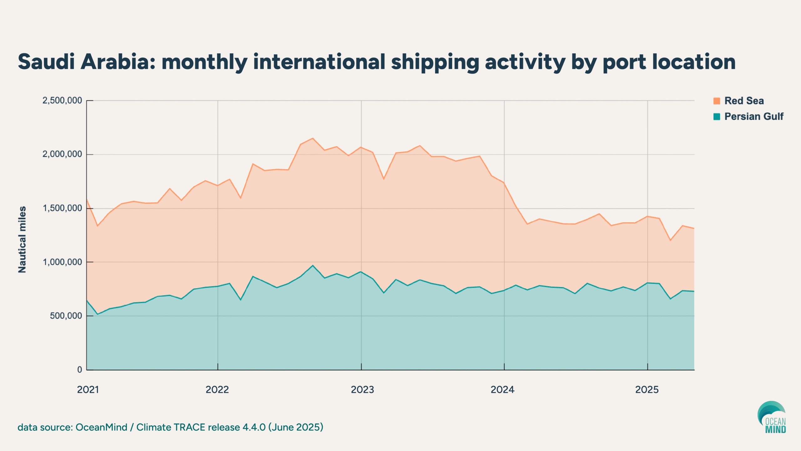
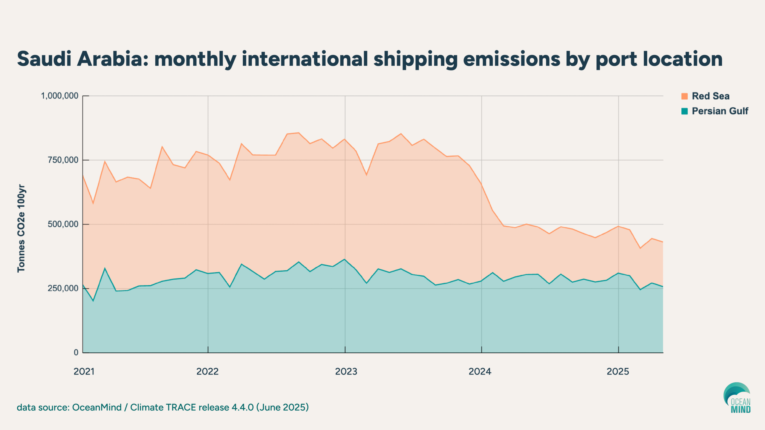
Below, OceanMind's monthly analysis charts the impact of these disruptions on both shipping activity and emissions. Using AIS devices and vessel characteristics like size and engine specifications, this approach tracks maritime patterns worldwide — including in the Red Sea region. Read on for a closer look at activity in the Red Sea versus the Persian Gulf, followed by a deep dive on port analytics at Jeddah and King Abdullah.

Saudi shipping activity and emissions: Red Sea vs. Persian Gulf

Overall, OceanMind's data present a clear picture of regional disruption. 

Saudi Arabia’s Red Sea ports experienced a steep drop in vessel activity, reflecting the impact of rerouting around the Cape of Good Hope. Activity here declined from more than 1.1 million nautical miles in 2023 to around 600,000 throughout 2024 and into 2025 — a roughly 45% decrease.

Meanwhile, the Persian Gulf — anchored by Saudi Arabia's busy port of Dammam — shows stable activity levels, unaffected by the Red Sea disruptions.

The emissions data tell a similar story. The Red Sea saw emissions drop even more dramatically than activity, falling from more than 500,000 to less than 200,000 tonnes CO2e 100yr — a roughly 60% reduction as fewer large vessels transit the waterway.

(Note: The data in this article are based on Climate TRACE release 4.4.0 from late June 2025, which includes international shipping data contributed by OceanMind. To determine port activity and emissions for trips between two ports, OceanMind tracks the movement of vessels, then assigns the nautical miles travelled and corresponding emissions split across the origin and destination ports. Estimated emissions while the vessel is staying in a port are all assigned to the respective port.)

Saudi Arabia: monthly international shipping activity by port location
Saudi Arabia: monthly international shipping emissions by port location

Port-Level Impact: Jeddah Islamic Port

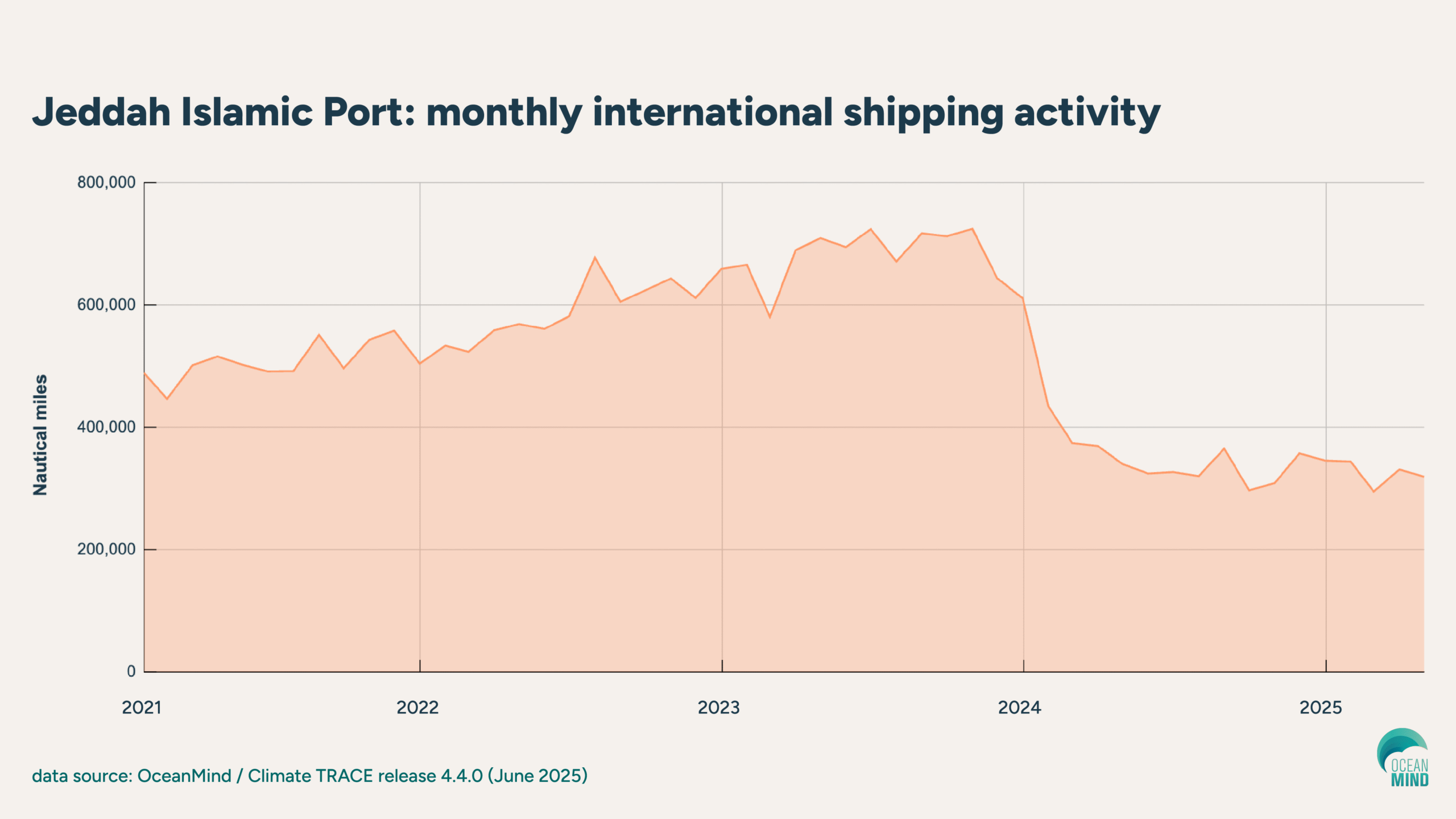
Jeddah, Saudi Arabia's largest container port on the Red Sea, shows a sustained drop in monthly activity from early 2023 levels to significantly lower volumes through 2024 and into 2025. The downturn aligns with major carriers rerouting away from the Red Sea amid escalating security risks.

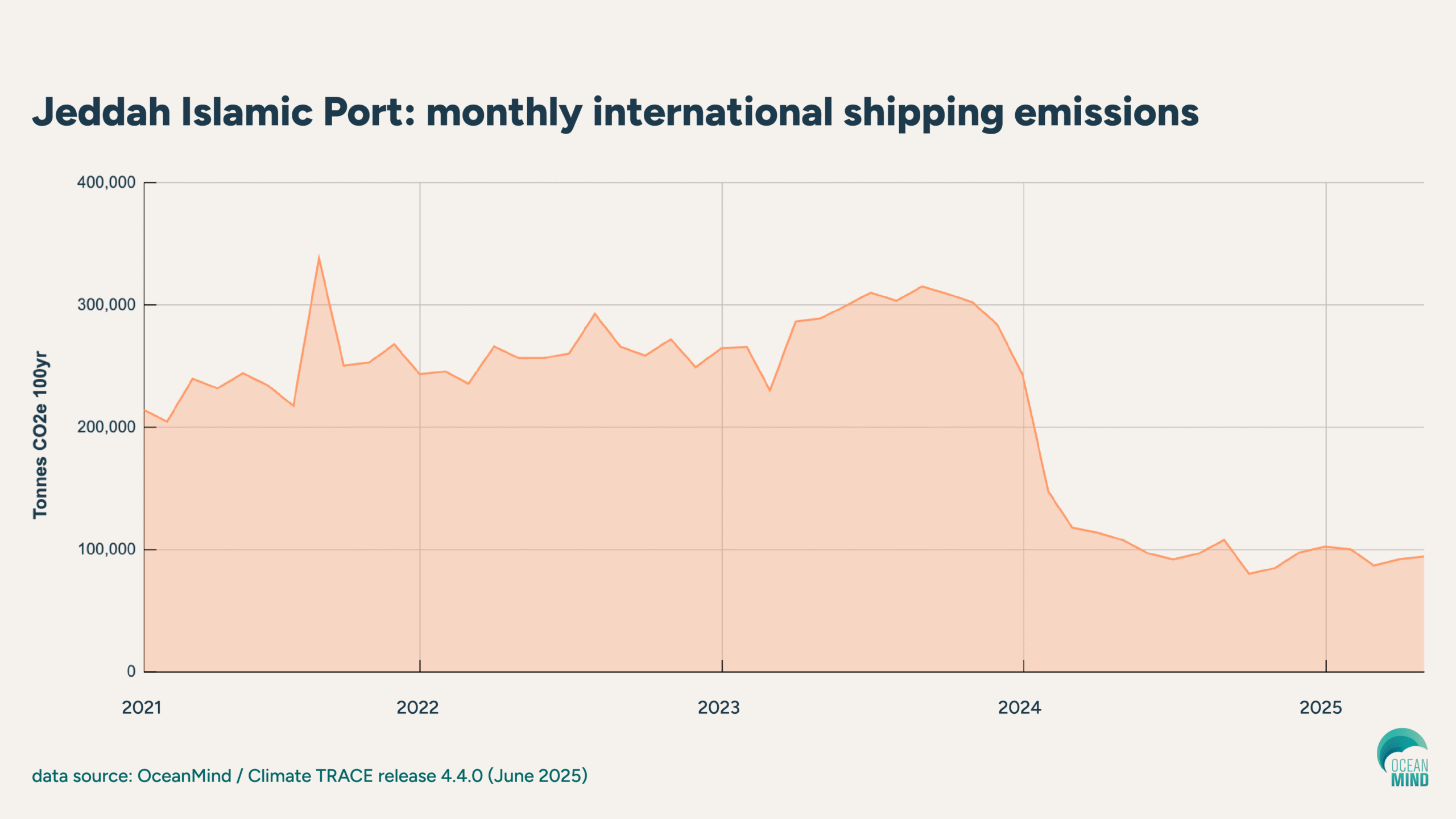
The emissions data for Jeddah follow the same pattern, with reduced ship traffic translating directly into lower shipping emissions assigned to the port. The data illustrate how closely port-level emissions track with vessel activity levels.

Jedah Islamic Port: monthly international shipping activity
Jeddah Islamic Port: monthly international shipping emissions

Port-Level Impact: King Abdullah Port

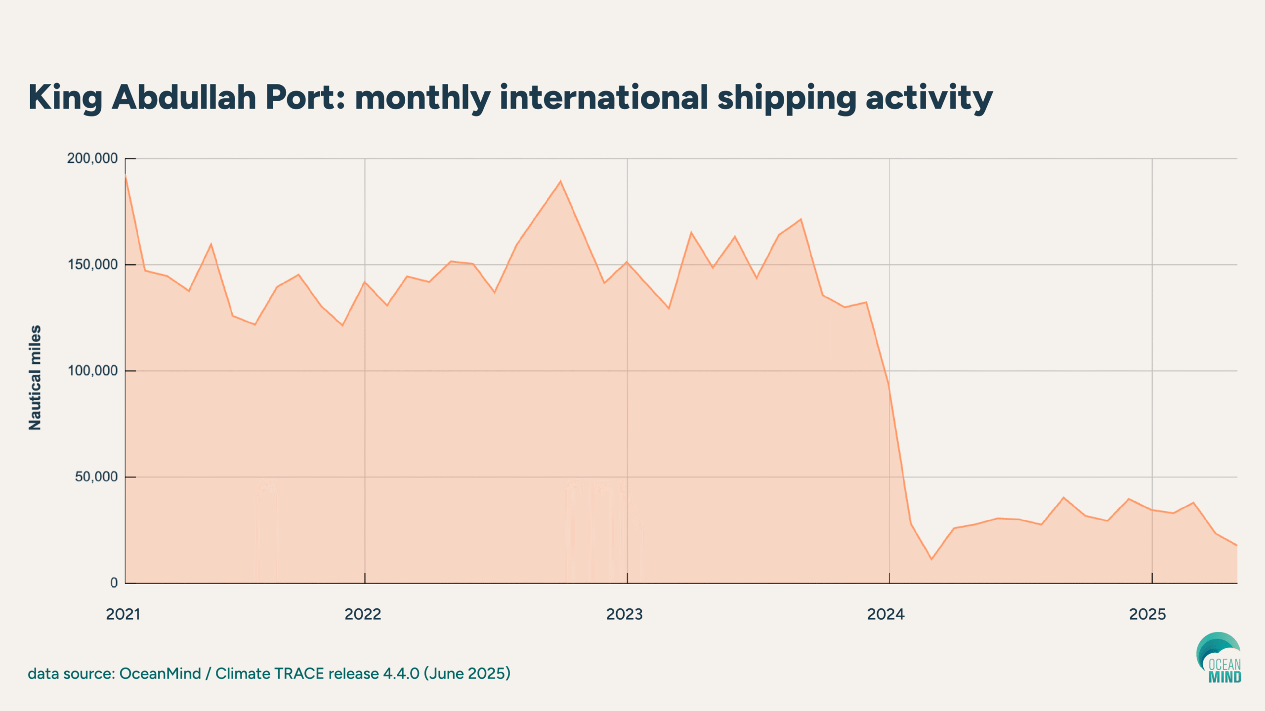
King Abdullah Port, previously one of the fastest-growing container terminals globally, shows an even steeper drop in vessel activity. Monthly activity levels have plunged dramatically, reflecting the near-total halt of deep-sea services since early 2024.

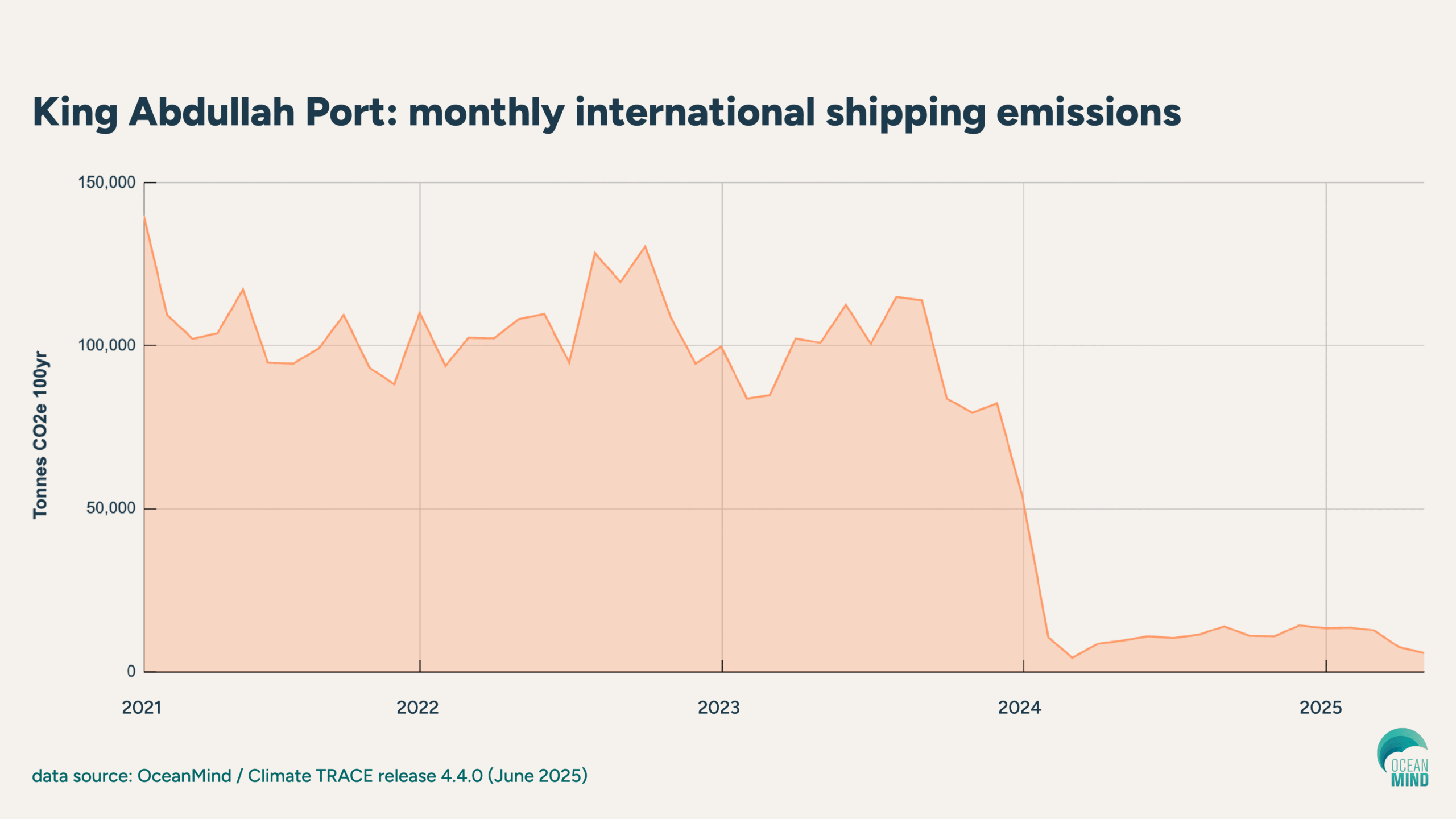
Correspondingly, emissions linked to shipping at King Abdullah Port have plummeted.

King Abdullah Port: monthly international shipping activity
King Abdullah Port: monthly international shipping emissions

Why granular data matter for maritime resilience

These snapshots reveal how deeply the Red Sea crisis has reshaped maritime traffic patterns across the region. Monthly, granular data like these — made freely available as part of OceanMind's role in Climate TRACE — transform how we understand and respond to global shipping disruptions. 

This kind of insight helps industry leaders and policymakers anticipate risks more clearly and adapt strategies to meet the realities of a shifting maritime landscape.

hero image: Jeddah Islamic Port, Saudi Arabia (iStock / eugenesergeev)

OceanMind unveils ZEROinFIVE initiative to combat IUU seafood imports

Oxfordshire, UK — 11 June 2025 — OceanMind, the impact organisation providing independent data intelligence to help protect the world’s ocean, today announces the launch of ZEROinFIVE, an initiative to stop all illegal seafood imports within five years by blocking illegally caught fish at ports.

Globally, an estimated 1 in 5 fish (20%) are caught illegally. In some countries, that number can reach as high as 50%. Such illegal, unreported, and unregulated (IUU) fishing is devastating marine ecosystems and harming honest fishers.

The Agreement on Port State Measures (PSMA) — a UN FAO international treaty established in 2009 — gives governments the legal right to block illegally caught fish from entering markets, stopping it before it lands in port. If fully implemented by all signatories, the PSMA would essentially make illegal fish unsellable, meaning catch cannot be converted to cash.

However, out of the 80 signatories of the agreement, most countries need more tools, data, and training to verify the origin of every imported catch and implement PSMA to maximum effectiveness.

Empowering governments and port authorities with stronger PSMA implementation support and capacity building

Crossing the bridge between PSMA’s potential and authorities’ capacity to enforce it is where OceanMind’s ZEROinFIVE initiative comes in.

“The challenge is monumental,” said Nick Wise, CEO, OceanMind. “But so is the opportunity. We have the legal framework and the technology — what we need now is coordinated action. Through ZEROinFIVE, we can equip nations with the tools and training to turn the PSMA from paper into practice, cutting off the pathways that allow illegal catch to reach consumers worldwide."

OceanMind’s planetary-scale technology, co-designed with Microsoft over the past 10 years, combines satellite surveillance with AI-powered risk assessments to streamline inspection planning, in-port investigation, and port use decision-making anywhere.

Harnessing these advanced technologies, OceanMind helps countries make confident, data-driven decisions to:

  1. Verify vessel histories,
  2. Detect IUU activities, and
  3. Deny access to port services.  

OceanMind’s capacity building programme begins with full support for PSMA risk assessments and inspection planning, followed by a complete handover and independent operation by the host country over a 12- to 24-month period.

Proven success in Thailand — and replicating the approach

Between 2015 and 2020, OceanMind supported Thailand authorities in a complete reform of its fisheries enforcement capability, including comprehensive PSMA implementation:

Following that success, OceanMind has also today announced at the third United Nations Ocean Conference a commitment to deliver this programme of capacity building in the Philippines and Cambodia, with the support of the Department of Fisheries and Oceans, Canada. Our newly launched ZEROinFIVE initiative aims to replicate and scale this approach globally.

OceanMind is ready to deploy this programme to all 80 signatories of the PSMA, closing every major port in the world to imported IUU fish. This would significantly reduce IUU fishing and the associated damage to the environment globally.

"We've proven this approach works in the regions where we've partnered with authorities," said Nick Wise. "Now we need philanthropic partners, collaborating governments, and participating authorities to help us rapidly scale. With expanded support, we can achieve what once seemed impossible: zero illegal seafood imports within five years. The ocean can't wait — but together, we don't have to."

Learn more about ZEROinFIVE, and talk to our team about how to support this work.

###

ABOUT OCEANMIND
OceanMind is a modern breed of impact organization that’s equal parts mission-centric nonprofit NGO and tech-enabled data and analytics provider. It provides independent data intelligence to help protect the world’s ocean and support the nations, companies, people, and economies that depend on it.

Learn more here: https://oceanmind.global/

MEDIA CONTACT
Nikki Arnone, Inflection Point Agency for OceanMind nikki@inflectionpointagency.com