Solution and Technology
Solution and Technology / UK MPA Project
Oceanmind used satellites, remote sensing, and drones to monitor fishing activity in UK Marine Protected Areas. The data collected and the techniques used have proven hugely useful to the Marine Management Organisation and the Inshore Fisheries and Conservation Authorities in their work to better protect UK fisheries.
The project used Electro-Optical and Synthetic Aperture Radar from satellites, combined with AIS, VMS, and iVMS data, which was analysed using Artificial Intelligence. These combined technologies allowed accurate identification of the location of a vessel, its activities and any signs of suspicious behaviour. Drones were also used for the first time in the trial sites to support enforcement patrol efforts, to collect evidence, and perform investigations.
To learn more about how the technology trials were conducted, see our Emerging Technology Assessment Report.
-
Synthetic Aperture Radar or SAR is the use of radar from space in order to detect features on the planet’s surface. The radar satellite sends an active radio pulse of a certain wavelength down to the surface and then measures the reflection. The satellite knows its location in orbit very precisely and so it can measure the length of time it takes for the pulse to return to calculate the height of features underneath, as well as how much the pulse is scattered or absorbed to understand the types of material reflected off. This makes it ideal for detecting metal vessels on the open ocean, as the ocean scatters or absorbs the signal while the vessel reflects it. Depending on the wavelength used it is also possible to measure the height of fixed features to millimetre accuracy.
The power of the pulse sent by a SAR satellite can either be spread across a wide area or focused on a small area. If over a wide area then the size of the object needed to reflect enough signal to be detected is quite large, for open ocean covering 250,000km2 (500km x 500km) vessels must be more than 20m long and made of metal to be reliably detected. For a small area of around 400km2 (20km x 20km) vessels over 1m can be detected, and in some conditions slightly larger vessels made of wood or fibreglass can also be detected albeit not consistently.
Due to the nature of SAR imagery, it is relatively straightforward to computationally process an image to automatically detect vessel positions within it. This automation allows for the rapid analysis of even large images to inform compliance investigations.
-
Electro-optical satellite imagery is essentially photography from space. Imaging satellites of these types range from having similar capabilities to the average smartphone up to massive telescopes that can see individual people on the street. The most familiar use of this type of imagery is in Google Maps.
Similar to SAR satellites, the sensor in an electro-optical satellite can gather light from a wide area or a focused small area. In the case of wide area coverage, the size of the objects in the image are lower resolution, so smaller. For small areas the observed objects appear larger and more detailed at higher resolution.
The specifics that can be observed depend very much on the individual satellite used. Free optical data can be obtained from the European Space Agency’s Sentinel-2 satellite, which provides data in 100km x 100km grids (covering 10,000km2 per image). Sentinel-2 has a range of optical sensors on board and records images in 13 different bands of light ranging through visible light to infrared. The size of the objects visible in images depends on the spectral band used, but ranges from 10m to 60m.
Commercial imagery can be obtained from a wide range of vendors, providing many combinations of footprint and resolution combinations. The highest resolution currently available can detect objects more than 25cm in size, but covers less than 200km2.
While it is more likely that small wood and fibreglass vessels can be detected using high resolution optical imagery, the nature of the imagery makes it harder to automatically extract these vessels from images. This results in the need for manual analysis of images to investigate non-compliance.
-
AIS is a safety of life at sea (SOLAS) system design to prevent collisions. It is a radio transponder on a vessel that transmits the current GPS coordinates of the vessel and other information such as its course and speed, size, identity, etc. The radio signal is broadcast by the vessel as it travels along, and received by nearby vessels so they can coordinate and avoid collision. AIS typically transmits several times per hour or even per minute depending on the manoeuvres undertaken. AIS is mandatory for any vessel over 300GT or passenger carrying vessels.
While not designed to be so received, AIS signals can be picked up from space by specially designed satellites. These signals are havested and sold commercially by various satellite vendors.
AIS has the benefit of being widely deployed and easily accessible for tracking vessel locations. Many countries and regional bodies now mandate the use of AIS on fishing vessels making it a valuable data source. The disadvantages are that AIS is easily tampered with to transmit incorrect or misleading information including falsifying GPS positions, it can be turned off at will, coverage is not guaranteed meaning vessels in busy locations or where there is no satellite overhead may not be visible, and the radio transmission can be corrupted as it travels through the atmosphere. This means that AIS can be used at-best as an indicator and always requires corroboration and further investigation.
-
VMS is a vessel tracking system designed for regulatory control of fishing. It is tamperproof and transmits location and supporting data over reliable satellite communications links.
Tamperproofing and use of satellite communications make this technology expensive with ongoing running costs, meaning it is typically only deployed on larger industrial and semi-industrial fishing vessels. The ongoing cost is proportional to the frequency with which data is reported. Typically data is provided once per hour, but sometimes can be as frequent as every 15 minutes. For the UK MPA Project data was available once every two hours.
VMS provides a strong foundation for regulatory enforcement due to its reliability. Disadvantages are cost and length of time between data transmissions. At two-hourly transmission rates it is possible for a vessel to fish in a protected area and withdraw between two transmissions.
-
iVMS attempts to overcome the cost disadvantage of VMS by reducing reliability requirements. Designed to support smaller scale fishing vessels for whom VMS would be too expensive, iVMS stores tracking data onboard and only transmits it when within range of a mobile phone network. Due to this ability to store data, iVMS records location on a much more frequent basis than VMS, often every few minutes.
iVMS provides for vessel tracking data where it otherwise would not be available due to cost. The higher rate of location reporting means that vessels cannot enter protected areas unnoticed. It retains elements of tamperproofing on data but loses reliability on transmission, and so is not a real-time solution. It is not useful for tracking vessels on the high seas, or that take multi-day fishing trips out of range of shore.
-
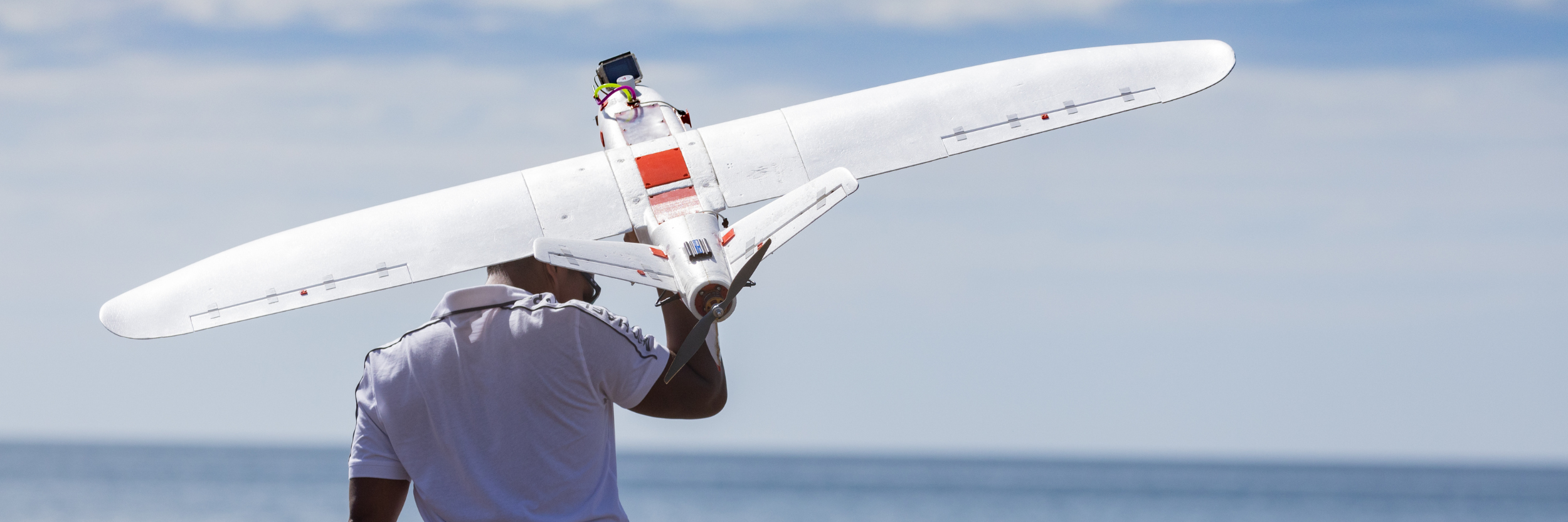
The term UAV, or drone, covers a wide variety of remotely controlled ariel vehicles ranging from large government devices with military applications to small portable quadcopter cameras available from toy shops. These vehicles are usually remotely controlled by a pilot from an onshore location, with devices either under full control of the pilot, or by having limited automation making them able to follow pre-programmed flight plans. UAVs can carry a range of different sensors from cameras to radar to heat sensors.
In the UK MPA Project we trialled a quadcopter remotely piloted ariel vehicle with a 30 minute flight duration and 6km maximum range. The quadcopter was licensed to extend up to 2km from the pilot. In order to take best advantage of these characteristics, the quadcopter was launched from a patrol vessel out at sea in order to gather evidence of fishing activities.
The benefit of this device is that it is straight forward to manage and deploy to gather photographic evidence in real time cost effectively. The disadvantages are limited range and flight time, and the need to be closer to the pilot. By selecting one of the many other types of drone these disadvantages can be overcome, usually through increased cost.
-
Artificial intelligence refers to a range of computer algorithms that allow computers to support decision making by analysing data and applying learned expertise. Machine learning is one such algorithm whereby the computer can learn to recognise patterns of behaviour, such as in this case different forms of fishing including longlining, trawling, or purse seining.
For the UK MPA Project OceanMind’s machine learning algorithms were used to recognise different types of fishing activity from AIS and iVMS data in order to sort and filter the huge data sets and focus human analyst time and attention on suspected non-compliance, streamlining investigations and increasing productivity of regulatory officials.
To find out more about these technologies and others that OceanMind employs, please contact info@oceanmind.global